|
|
CAPE GARDEN ROUTE
GEORGE MOSSEL BAY KNYSNA PLETTENBERG BAY OUDTSHOORN TSITSIKAMMA |
The Garden Route is a popular and scenic stretch of the south-eastern coast of South Africa. It stretches from Mossel Bay in the Western Cape to the Storms River which is crossed along the N2 coastal highway over the Paul Sauer Bridge in the extreme eastern reach of the Western Cape.
The name comes from the shrubbery near the coast. It includes towns such as Mossel Bay, George, Knysna, Oudtshoorn, Plettenberg Bay and Nature's Valley. It has a maritime climate, with moderately hot summers, and mild to chilly winters. It is one of the nicest all-year-round rainfall areas in South Africa, most rain falling in the winter months, brought by the humid sea-winds from the Indian Ocean rising and releasing their precipitation along the high mountain ranges just inland of the coast.
The Route is sandwiched between the Outeniqua and Tsitsikamma mountains and the Indian Ocean. The Outeniqua and Tsitsikamma indigenous forests are a unique mixture of Cape Fynbos and temperate forest and offer hiking trails and eco-tourism activities. Nearly 300 species of birdlife are to be found in a variety of habitats ranging from fynbos to forest to wetlands.
Ten nature reserves embrace the varied ecosystems of the area as well as unique marine reserves, home to soft coral reefs, dolphins, seals and a host of other marine life.
Various bays along the Garden Route are nurseries to the endangered Southern Right Whale which come there to calve in the winter and spring (July to December). Although the most popular exploration of the Garden Route is by car, it is also the site of Africa's last remaining passenger steam train, the Outeniqua Choo Tjoe. http://en.wikipedia.org/wiki/Garden_Route
GEORGE - (For George Accommodation go to George Accommodation ) The city is situated halfway between Cape Town and Port Elizabeth on the Garden Route. It is situated on a 10 kilometre plateau between the Outeniqua Mountains to the north and the Indian Ocean to the south.
George nestles at the foot of the Outeniqua Mountains. When visiting George, don't miss the Dutch Cheese Farm for wine and cheese tasting, the Red Berry Farm where you pick your own strawberries, he Bado Kidogo Bird Farm and the Garden Route Botanical Gardens- the only botanical garden on the Garden Route.
The Outeniqua Choo-Tjoe train runs between George and Knysna. This steam train journey offers amazing views.
MOSSEL BAY - (For Mossel Bay Accommodation go to Mossel Bay Accommodation ) Mossel Bay lies on the southern coast of South Africa, east of the Cape of Good Hope and west of Knysna. It lies on the Indian Ocean coast and is part of the Garden Route.
Portuguese explorer Bartolomeu Dias arrived here on February 3, 1488, thus proving to his sponsors that Africa had a southern tip; making it theoretically possible to sail from Europe to India. Originally called by Dias Aguada de São Brás (Bay of Saint Blaise), the harbour and surrounding area was renamed Mosselbaai (Bay of Mussels) in 1601 by Dutch navigator Paulus van Caerden, as he found the bay to be abundant with mussels. This popular holiday town is surrounded by the refreshing waters of the Indian Ocean. It is a busy summer destination as well as an ideal winter retreat. It is blessed with a mild climate all-year round and is the historical capital of the Garden Route. Well-traveled pleasure boats dock regularly and Mossel Bay is a rapidly growing tourist destination as more and more travelers are discovering the Jewel of the Cape Garden Route.
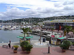
KNYSNA - (For Knysna Accommodation go to Knysna Accommodation )
Knysna , probably from a Khoikhoi word meaning "ferns")is a town in the Western Cape Province of South Africa and is part of the Garden Route. It lies 34 degrees south of the equator, and is 72 kilometres east from the town of George on the N2 highway, and 25 kilometres west of Plettenberg Bay on the same road.
The town is primarily built on the northern shore of a large warm-water estuary, fed by the Knysna River. The estuary opens to the ocean after passing between two large headlands. These are popularly known as the "The Heads", and have become infamous due to the loss of boats and fishermen passing through their treacherous and unpredictable waters. Near them are geological formations, known locally as "The Map Stones."
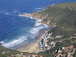
The town is a popular destination for both tourists and senior citizens entering retirement. Recently the town has also become a preferred destination among golfers, as the town boasts several world class golf courses. Knysna too is a favourite haunt of artists, restaurateurs and hippies. The nearest beach is located at Brenton-on-sea which lies directly west of the heads and is continuous with Buffels Bay, a popular surf spot. Knysna's other claims to fame are as the end point of the Outeniqua Choo Tjoe steam railway, and as home to the fabled Knysna forest elephant.
PLETTENBERG BAY - (For Plettenberg Bay Accommodation go to Plettenberg Bay Accommodation )
Plettenberg Bay, nicknamed Plet or Plett, is a town in the Western Cape Province of South Africa. It was originally named Bahia Formosa (beautiful bay) by early Portuguese explorers and lies on South Africa's Garden Route 210 km from Port Elizabeth and about 600 km from Cape Town.
Tourism is a thriving industry in this area, starting in November when teenage school leavers are the first to descend upon the small town, followed thereafter by various waves of arrivals from abroad as well as other parts of South Africa.
Plettenberg Bay is also home to a multi-species free-roaming primate sanctuary called Monkeyland, as well as a large bird cage at the Birds of Eden Sanctuary.
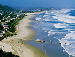
The white, sandy beaches around the town are very popular with tourists, who have the following to choose from: Robberg Beach Beacon Island Beach Lookout Beach (flood-ravaged in November 2007)
OUDTSHOORN - (For Oudtshoorn Accommodation go to Oudtshoorn Accommodation )
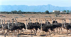
Oudtshoorn is a town in the Western Cape province in South Africa.Is the largest town in the Little Karoo region. The town is home to the world's largest Ostrich population with a number of specialized ostrich breeding farms such as the Safari Show Farm and the Highgate Ostrich Show Farm.
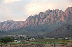
The area in which Oudtshoorn is situated was originally inhabited by the Bushmen, as evidenced by the many rock paintings that are found in caves throughout the surrounding Swartberg mountains.
iN 1869 there was a large rise in prosperity due to the ostrich, whose feathers had become extremely popular as fashion accessories in Europe; they were especially popular for use on hats. Between 1875 and 1880 ostrich prices reached up to GBP 1,000 a pair.
The farmers of the region, realising that ostriches were far more profitable than any other activity, ripped out their other crops and planted lucerne, which was used as feed for the ostriches.
Owing to overproduction, the ostrich industry experienced a sudden slump in fortunes in 1885; the town's misery was compounded when it was hit by severe flooding during the same year, which washed away the nearby Victoria Bridge which had been built over the Olifants River only the year before.
The ostrich industry recovered only slowly and it was not until after the Second Anglo-Boer War of 1899 to 1902 that a second and bigger boom started. It was during this period that most of Oudtshoorn's famously opulent "Feather Palaces" were built. This boom peaked in 1913, before collapsing in 1914. As a result the region's economy was ruined and most farmers returned to more traditional crops. The Oudtshoorn of today is a large and modern town that relies mostly on tourism, farming and the ever-present ostrich industry for most of its economic activity.
TSITSIKAMMA - (For Tsitsikamma Accommodation go to Tsitsikamma Accommodation )
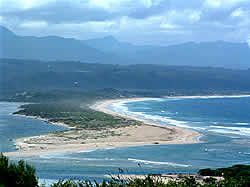
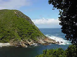
The word tsitsikamma is a Khoisan phrase meaning place of abundant water. The Tsitsikamma National Park is a coastal reserve on the Garden Route in South Africa. It is well known for indigenous forests, dramatic coastline, and the Otter Trail.
On 6 March 2009 it was amalgamated with the Wilderness National Park and various other areas of land to form the Garden Route National Park. The park covers an 80 km long stretch of coastline.Nature's Valley is at the western end of the park, and the main accommodation is at Storms River Mouth. Near the park is the Bloukrans Bridge, the world's highest bungee jump at 216m.At Storms River there are various amenities, including a restaurant, shop, chalets, camp site and caravan park, information centre, the Agulhas lookout platform, trees marked with their national tree list numbers and underwater trails.
|
|
|||||||||||||||