|
|
THE CASTLE OF GOOD HOPE
The Castle of Good Hope is a fortification which was built on the original coastline of Table Bay and now, because of land reclamation, seems nearer the centre of Cape Town, South Africa. Built by the VOC between 1666 and 1679, the Castle is the oldest building in South Africa. It replaced an older fort made out of clay andtimber that was built in 1652 by Jan van Riebeeck upon his arrival at the Cape of Good Hope. The purpose of both were to act as replenishment station for ships passing the treacherous coast around the Cape on long voyages between the Netherlands and the Dutch East Indies.During 1664, tensions between Britain and the Netherlands rose with rumours of war being imminent — that same year, Commander Zacharius Wagenaer was instructed to build a pentagonal castle out of stone. On 26 April 1679, the five bastions were named after the main titles of William III of Orange-Nassau: Leerdam to the west, with respectively Buuren, Katzenellenbogen, Nassau and Oranje clockwise from it.The Castle replaced the first fort built by Jan van Riebeeck, which was the first Cape Town's first building.The Houses of Parlement, St George's Catherdral, South African National Gallery, Tuynhuys and other buildings of historical importance are housed in The Company's Gardens, as well as the South African Museum & Planetarium, The Michaelis School of Fine Arts, The Little Theatre, Bertam House and a Tea Garden, a lovely park with Rose Gardens, Fountains, Statues and wonderful fish ponds along the pathways. Take a walk through Government Lane and feed the Squirrels.
|
Table Mountain National Park
Table Mountain National Park, previously known as the Cape Peninsula National Park, is a national park in Cape Town, South Africa, proclaimed on May 29, 1998 for the purpose of protecting the natural environment of the Table Mountain Chain, and in particular the rare fynbos vegetation. The park is managed by South African National Parks.
The park contains two well-known landmarks: Table Mountain, for which the park is named; and the Cape of Good Hope, the southwesternmost extremity of Africa.
|
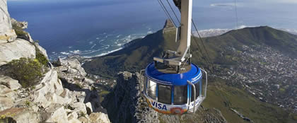
TABLE MOUNTAIN CABLE CAR |
 |
Rates valid from 1 October 2016 to 30 September 2017 (excludes 15 December 2016 – 15 January 2017):
300
Adult - Return:R250
Child 4-17 years of age :Return R125
SA student (Fridays only at Ticket Office) R130
SA senior citizen (Fridays only at Ticket Office) R100 RETURN
Opening Hours
Summer -
First Car Up 08h00
Winter -
First Car Up 08h00
|
Directions to the Cableway are clearly signposted - look out for information boards.
The Table Mountain Cableway takes passengers from the lower cable station on Tafelberg Road, about 302 m above sea level, to the plateau at the top of the mountain.
The upper cable station offers views overlooking Cape Town, Table Bay and Robben Island to the north, and the Atlantic seaboard to the west and south.
Construction of the cableway was first started in 1926, and the cableway was officially opened in 1929. In 1997, the cableway was extensively upgraded, and new cars were introduced carrying 65 instead of 25 passengers.
The new cars gave a faster journey to the summit, and could rotate through 360 degrees during the ascent or descent, giving a panoramic view over the city.
Reference: Wikipedia |
|
|
TABLE MOUNTAIN
Table mountain is a famous landmark and tourist attraction in Cape Town, with many visitors using the cableway to take a ride to the top. The mountain is named for its flat top which is often covered by cloud, forming the "table cloth". It stands 1,086 m above sea level at its peak and the main face is approximately 3 km from side to side.The top of Table Mountain is approximately 3km wide, and at its heighest point, Maclears Beacon, rises to 1085m.Table Mountain is a sandstone plateau. It is one of South Africa's most famous landmarks. The steep cliffs and rocky outcrops of the mountain are home to a number of plants and animals. There are approximately 1470 species of plants. Many fauna also inhabit the mountain. The Table Mountain Ghost Frog, being found in no other place in the world. Apart from the views, there are also curio shops, a restaurant and walking trails for visitors at the top of the mountain.
Hiking on Table Mountain is popular amongst locals and tourists, and a number of trails of varying difficulty are available. Because of the steep cliffs around the summit, direct ascent from the city side is difficult. Longer routes to the summit go via the Back Table, a lower area of Table Mountain south of the main plateau. There are paths to the Back Table from both the Atlantic and Southern Suburbs sides, and from there a number of paths make a gradual ascent to the summit.
Among the most popular routes are:
* Hoerikwaggo Trail
* Jeep Track a.k.a. the Bridle Path
* Kasteelspoort
* Nursery Ravine
* Pipe Track
* Platteklip Gorge
* Skeleton Gorge |
| |
BIRDS OF EDEN |
Birds of Eden's unique two hectare dome (the World’s largest) spans over a gorge of indigenous forest. |
 |
BIRDS OF EDEN
Birds of Eden's unique two hectare dome (the World’s largest) spans over a gorge of indigenous forest. The sanctuary has its own mysterious ruin, which incorporates a walk-behind waterfall. Another feature is its amphitheatre, which has the ability to seat over 200 visitors.
Birds of Eden is situated next to Monkeyland, and similar to Monkeyland requires no pre-booking unless a multi-lingual guide is required for a guided tour.
|
 |

Please email us your queries to
info@monkeyland.co.za
Entry to Monkeyland is free; this entitles you to spend time on the forest deck, which also doubles as a restaurant named The Blue Monkey Cafe. |
|
| |
Entry to Monkeyland is free; this entitles you to spend time on the forest deck, which also doubles as a restaurant named The Blue Monkey Cafe.
The difference between Monkeyland and Birds of Eden is that you are able to stroll about the bird sanctuary without a safari guide whereas you cannot do so at Monkeyland
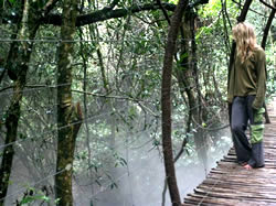
From this area primates moving about the forest are always seen, and heard. The only charge is to go on a monkey safari (optional) with one of our game rangers, this is a foot safari into the forest where the primates have been released and are free roaming. The rangers will track the primates down & impart interesting information about them, the forest and anything else you come across. Part of the safari is across our 128 m canopy walk, which actually rises above the forest canopy for a birds eye view of this primate paradise. These walking safaris last an hour, and depart from reception each half hour. The tours depart daily, every half hour and are open-ended which means that you can go on more than one tour on the day you are visiting us.
Birds of Eden is situated next to Monkeyland, and similar to Monkeyland requires no pre-booking unless a multi-lingual guide is required for a guided tour. The difference between Monkeyland and Birds of Eden is that you are able to stroll about the bird sanctuary without a safari guide whereas you cannot do so at Monkeyland.
We always advise visitors to try an allocate an minimum of 4 hours for their visit to Monkeyland, Birds of Eden and The Jukani Wildlife Sanctuary. If you allocate less time, you might miss out. Our sanctuaries are tranquil and worth hanging out at for the day. |
| |
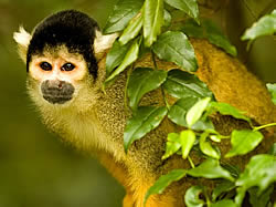
Monkeyland Primate Sanctuary- a true primate sanctuary |
Please email us your queries to
info@monkeyland.co.za
Entry to Monkeyland is free; this entitles you to spend time on the forest deck, which also doubles as a restaurant named The Blue Monkey Cafe. The only charge is to go on a monkey safari
Monkeyland Primate Sanctuary
Monkeyland is the worlds first free roaming multi-specie primate sanctuary. Monkeyland has as one of its aims, to create awareness about the plight of primates.
It offers tours (monkey safaris) where guests can view the 500+ resident primates in their forest home, there is also a restaurant, souvenir store and viewing deck, and a 128 metre suspended canopy walk. Monkeyland’s safari guides are multi-lingual,
|
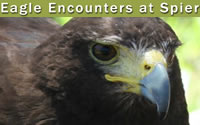
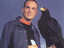
| EAGLE ENCOUNTERS |
Please contact Tracy Chalmers for further details
eagles@telkomsa.net
Tel : +27 (0)21 858-1826
Spier Estate
Lynedoch Road (R310) Stellenbosch
Monday to Sunday
09:00 - 17:00
Eagle Encounters
ENTRANCE FEES:
- Adults pp R70
- Children (3 to 12 years) R60
- Students (with Student ID Card proof) R65
- Pensioners (ID may be requested) pp R65
|
INCLUDES:
- 4 interactive flying shows
- 2 interactive African Porcupine shows
- personal interactions with African Wood Owls, our famous dancing Barn Owls, Bengal Eagle Owls, snakes, Bearded Dragons etc
- having the Spotted Eagle Owls in the front enclosure flown to you!
Eagle Encounters receives birds that have been injured, poisoned, abused and hand-reared.Our first priority, in every case, is to rehabilitate and release as soon as possible. Only hand-reared birds are retained for education purposes. Did you know Eagle Encounters is a self-funded Non-Profit Organization. Your support funds our rehabilitation, education, conservation & community outreach programmes.
|
| |
| GOLD OF AFRICA MUSEUM |
The museum is home to a collection of 350 West African gold artefacts as well as objects from the ancient gold civilisation of southern Africa. The purpose of the collection is to preserve the art of African goldsmithing while inspiring contemporary design.
Gold of Africa museum
Martin Melck House,
96 Strand Street,
Cape Town
Tel: +27 (0)21 405 1540
museum@goldofafrica.com
Gold of Africa Museum is in the Cape Town CBD and is therefore easily accessible by road.
Tour for adults: R40 (Pangolin tour - R70); children under 10: R25
|
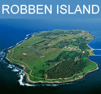
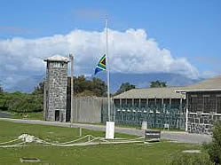
| ROBBEN ISLAND & NELSON MANDELA |
Standard Ticket Sales
CLICK HERE for email bookings info
Ferry tickets cost R280 for adults and R150 for children under 18
ROBBEN ISLAND
The three and a half hour tour includes a return trip across Table Bay, a visit to the Maximum Security Prison, interaction with an ex-political prisoner and a 45 minute bus tour with a guide providing commentary.
Concession rates to schools and disadvantaged groups are also considered on application to the Education and Marketing departments respectively.Reference: Wikipedia
|
Robben Island was first inhabited thousands of years ago by stone age people, at a time when sealevels were considerably lower than they are today and people could walk to it. It was then a flat-topped hill. Robben Island has been used to isolate certain people — mainly prisoners — and amongst its first permanent inhabitants were political leaders from various Dutch colonies, including Indonesia.From 1836 to 1931 the island was used as a leper colony and in the 20th century it became infamous as a gaol for political prisoners under apartheid. Notable amongst these were Nelson Mandela, Walter Sisulu, Tokyo Sexwale, Govan Mbeki and Robert Sobukwe.
During the time that the island was a prison, security was very tight and it was off limits to almost all civilians, including fishermen. Before about 1980 there was not one citizen in 10,000 in Cape Town who had set foot on the island. It is not generally known that the use of the island as a prison was greatly inhibited for centuries by a lack of fresh water. The island is arid, with low scrubby vegetation and has no watercourses. Boreholes were drilled in the first half of the 20th century but in due course the fragile water table was invaded by sea water and the bores became useless. All the land on the island is owned by the State, with the exception of the island church.
Today the island is a popular tourist destination and was declared a World Heritage Site in 1999. It is reached by ferry from the Victoria & Alfred Waterfront in Cape Town and is open throughout the year, weather permitting. Robben Island Museum (RIM) operates as a site or living museum. |
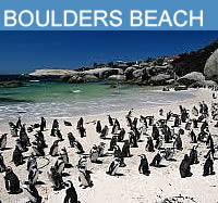
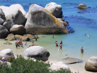
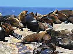
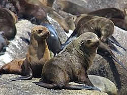
BOULDERS BEACH |
3 pristine beaches, 1 penguin viewing area and 3 boardwalks. |
For more information on how to help the plight of the African Penguin, contact SANCCOB on +27(0 21 557 6155
Boulders Beach forms part of the Table Mountain National Park. Boulders Penguin Colony in Simons Town is home to a unique and endangered land-based colony of African Penguins.
This colony is one of only a few in the world, and the site has become famous and a popular international tourist destination.
|
The Boulders section of TMNP consists of 3 pristine beaches, 1 penguin viewing area and 3 boardwalks. The boardwalks were built as a measure to allow for viewing of these wonderful birds, whilst keeping them safe from poking fingers. |
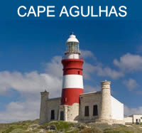
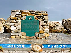
CAPE AGULHAS |
Cape Agulhas is the southernmost point in the continent of Africa. |
Cape Agulhas is actually the southernmost point in the continent of Africa. The Cape was named by Portuguese navigators, who called it Cabo das Agulhas -Portuguese for "Cape of Needles" - in reference to the rocks and reefs that have wrecked many ships in the area. The Cape is within the Cape Agulhas Municipality of the Western Cape Province of South Africa.
|
The Cape is defined by the International Hydrographic Organization to be the dividing point between the Indian and Atlantic oceans. South of Cape Agulhas the warm Agulhas Current that flows south along the east coast of Africa retroflects back into the Indian Ocean. While retroflecting it pinches off large ocean eddies (Agulhas rings) that drift into the South Atlantic Ocean and take enormous amounts of heat and salt into the neighboring ocean. This mechanism constitutes one of the key elements in the global conveyor belt circulation of heat and salt.The waters near the coast are quite shallow and are renowned as one of the best fishing grounds in South Africa.
The rocks that form Cape Agulhas belong to the Table Mountain Group, often loosely termed the Table Mountain sandstone. They are closely linked to the geological formations that are exposed in the spectacular cliffs of Table Mountain, Cape Point and the Cape of Good Hope.
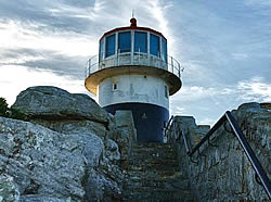
The lighthouse at Cape Agulhas has guided many ships around the Cape over the years.The sea off Cape Agulhas is notorious for winter storms and mammoth rogue waves, which can range up to 30 metres (100 ft) high and can sink even large ships.
These conditions are caused by a number of factors. The naturally strong winds of the roaring forties, which blow from west to east, and the cold Antarctic Circumpolar Current flowing in the same direction, come up against the warmer Agulhas Current in the region of the Cape. These conflicting currents of water of different densities, and the west winds blowing against the Agulhas Current, can create extremely hazardous wave conditions; these are further exacerbated by the shallow waters of the Agulhas Bank, a broad, shallow part of the continental shelf which juts 250 kilometres (155 mi) south from the Cape, after which it falls steeply away to the abyssal plain.
These hazards have combined to make the Cape notorious among sailors; the coast here is littered with wrecks. Cooranga, Elise, European, Federal Lakes, Geortyrder, Gouritz and Gwendola are just a few of the vessels lost at the "Cape of Needles".[3] Owing to the hazards and following the loss of several vessels, a lighthouse was built in 1848. |
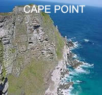
CAPE POINT |
Cape Point is a promontory at the south-east corner of the Cape Peninsula |
Visitor centre:
+27 21 780 9010
Email us for maps and further info at
info@capepoint.co.za
Flying Dutchman Funicular saves visitors a long uphill walk from the car park to see the old lighthouse and enjoy the panoramic views.
Cape Point is a promontory at the south-east corner of the Cape Peninsula, which is a mountainous and very scenic landform that runs north-south for about thirty kilometres at the extreme southwestern tip of the African continent in the Republic of South Africa.
|
Cape Point is often mistakenly claimed to be the place where the cold Benguela Current of the Atlantic Ocean and the warm Agulhas Current of the Indian ocean collide. In fact, the meeting point fluctuates along the southern and southwestern Cape coast, usually occurring between Cape Agulhas and Cape Point.
The two intermingling currents help to create the micro-climate of Cape Town and its environs. Contrary to popular mythology, the meeting point of the currents produces no obvious visual effect; there is no "line in the ocean" where the sea changes colour or looks different in some way. There are, however, strong and dangerous swells, tides and localized currents around the point and in adjacent waters. These troubled seas have witnessed countless maritime disasters in the centuries since ships first sailed here.
Fishing is good along the coast but the unpredictable swells make angling from the rocks very dangerous. Over the years scores of fishermen have been swept to their deaths from the rocky platforms by freak waves. False Bay, which opens to the east and north of Cape Point, is the location of the well-known naval port of Simon's Town. The bay is also famous - or infamous - for its great white sharks, which hunt the Cape Fur Seals that live in the area.
Although these two rocky and beautiful Capes are very well-known, neither Cape is actually the southernmost point in Africa; that is Cape Agulhas, approximately 150 kilometres (90 mi) to the south-east.
The peak above Cape Point is a little higher than that above the Cape of Good Hope. The rugged sandstone (Table Mountain sandstone) ridge that rises from Cape Point at sea level develops into two peaks. There is a major peak that dominates the skyline locally but there is also a smaller peak about 100 m further south. The higher peak has the old lighthouse on the top.
A funicular railway runs from a car park to the north up to slightly below the level of the old lighthouse and a short flight of steps leads to a viewing platform at the base of the lighthouse. From the end of the railway a second path leads to the lower peak.The new lighthouse is at sea level, for two reasons. Foggy conditions often prevail at the higher levels, and the old lighthouse could be seen 'too early' by ships rounding the point towards the east, causing them to approach too closely. The new location cannot be seen from the West until ships are at a safe distance to the South.
Both the Cape of Good Hope and Cape Point are situated within the Table Mountain National Park, the Cape Point section of which occupies the whole of the southern tip of the Cape Peninsula and which takes in perhaps 20% of its total area. The park is generally wild, unspoiled and undeveloped and is an important haven for seabirds.
|
| |
CAPE PENINSULA NATIONAL PARK
One of the most spectacular drives in the world. From Cape Town around the Peninsula along the False Bay coastline via Cape Point and back along the Atlantic coast via Hout Bay, Clifton's famous beaches and Sea Point.
COMPANY'S GARDEN
Situated at the very top of Adderley Street in Cape Town City Centre, the Company's Garden was originally established to provide fresh fruit and vegetable for the seamen sailing from Holland to Indonesia. The beautiful Garden is home to several landmark buildings including Parliament, SA Museum, SA National Gallery, Slave Lodge, St George's Cathedral, the Jewish Museum and the university of Cape Town's City Campus |
| |
CANGO CAVES : |
Email us for more detailed information at :info@cangocaves.co.za
Tel: +27 44 272 7410
Fax: +27 44 272 8001
In order to conserve and preserve the Cango Caves, we have instituted a limited amount of visitors per touring option.
CANGO CAVES : There are two tours to choose from. One is a Standard tour that takes about 60 minutes and the other is an Adventure tour that takes about 90 minutes.
Bookings are essential to guarantee your place.
Standard Tours: 09h00 - 16h00
(depart every hour on the hour)
Duration: ± 60 minutes
|
Adventure Tours: 09h30 - 15h30
(depart every hour on the half-hour)
Duration: ± 90 minutes
Open every day except Christmas Day
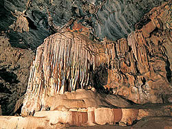
The Cango Caves are located in Precambrian limestones near the town of Oudtshoorn in the Western Cape Province of South Africa. The principal cave is one of the country's finest, best known and most popular tourist caves and attracts many visitors from overseas. Although the extensive system of tunnels and chambers go on for over four kilometers, only about a quarter of this is open to visitors, who may proceed into the cave only in groups supervised by a guide.
Tours are conducted at regular intervals on most days - there is a "Standard Tour" which takes an hour and an "Adventure Tour" which takes an hour and a half. The caves contain spectacular halls and grand limestone formations (on both tours) as well as some rather small passages on the Adventure Tour. The smallest passage that tourists will have to pass through on the Adventure Tour is just under 30cm high at the exit.
The caves are considered as a part of the Garden Route. |
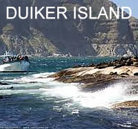
DUIKER ISLAND BOAT TRIPS |
There are daily boat trips to Duiker Island at a most affordable rate.
See Things to Do
Duiker Island
Duiker Island or Duikereiland (Afrikaans), also known as Seal Island (not to be confused with the nearby Seal Island), is an island off Hout Bay near Cape Town South Africa. It is 77 by 95 metres in size, with an area of about 0.4 hectare.
The island is renowned for its marine wildlife such as birds and fur seals. It is visited regularly by tourists and photographers by boat via Mariner's Wharf in Hout Bay harbour.
|
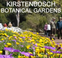
| KIRSTENBOSCH NATIONAL BOTANICAL GARDENS |
Kirstenbosch National Botanical Gardens
Founded in 1913, Kirstenbosch lies on the eastern slopes of Table Mountain. It consists of landscaped gardens of indigenous plants and trees, watered by the Liesbeek River, as well as natural forest that extends up the lower slopes. Kirstenbosch covers an area of 828Ha, 60 ha of which are cultivated; the remainder is a natural flora reserve.
|
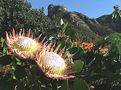
It is a living display featuring 4 700 of the estimated 20 000 species of indigenous South African flora, and close to 50 per cent of the Peninsula's floral wealth. In the cultivated area, related plants are grouped together and radiate from the central lawns like the spokes of a wheel.
Among the interesting sections here are the Cycad Amphitheatre, which hosts most species of these 'living fossils' found in southern Africa; the famed Protea Garden on the higher slopes, with its profuse growth of silver trees (Leucadendron argenteum); the JV Mathews Rock Garden (named after the first curator) containing succulents of the genera Crassula, Aloe, Lampranthus and Euphorbia; the Erica Garden and the Pelargonium Koppie.
Two streams cut through Kirstenbosch, both laced with besembos, red alder and hard fern. Of historical interest is an avenue of camphor trees and fig trees planted by Cecil Rhodes in 1898, and a small section of wild almond ( Brabejum stellatifolium) hedge planted by Dutch settler Jan van Riebeeck in 1660.
There are two special routes along level, paved paths for wheelchairs, prams or the less agile. Known as the Weaverbird Walk and the Silver Tree Stroll, both are clearly signposted with the wheelchair sign. Three trails, Silvertree, Yellowwood and Stinkwood Trails, provide more vigorous walks of up to 6 km or three hours.
The Braille Trail for the blind passes through natural Table Mountain forest and fynbos. The plants are dearly labelled with Braille and large-print labels.
The Fragrance Garden, situated nearby boasts a fine collection of indigenous aromatic plants, also labelled in Braille and large print, set out in a number of raised beds.
Within the grounds of Kirstenbosch are the headquarters of the National Botanical Institute that administers the national network of gardens and associated research institutes. One, the Compton Herbarium, is situated at the top of Camphor Avenue in Kirstenbosch itself. Named after a former director, the Compton Herbarium is dedicated to research, particularly into Cape flora.
It now preserves approximately 250 000 specimens, including its own collection and that of the South African Museum dating from 1825.
All paths in the main section of Kirstenbosch are paved. Smuts Track (used by the late General J C Smuts) leads through the mixed forest of indigenous trees up Skeleton Gorge to the summit of Table Mountain. The other route, Forest Walk, leads through leafy palaces of ironwood, yellowwood and red alder.
Kirstenbosch may be visited in spring and summer when the gardens blaze with Namaqualand daisies and other annuals, but winter is the best time to see proteas and ericas.
Visitors may purchase selected indigenous plants, books and souvenirs from the shop and there is a restaurant with an attractive outdoor section.
|
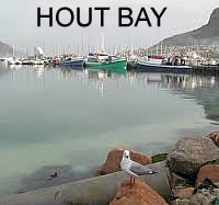
HOUT BAY |
Hout Bay is a thriving village with a variety of shops, restaurants and places of interest that will make any visit worthwhile.
The Hout Bay harbour is the 9th most visited tourist attraction in Cape Town and includes a yacht and boat marina, a working fishing fleet (and factories), a craft market, spectacular views of the bay and boat rides to Duiker Island and around the Sentinel.
|
Hout Bay boasts fine mountain walks with indigenous plants of over 1 100 species - making it one of the richest botanical areas in the world.
Other attractions include a beach, art galleries, Sunday craft markets on the village green, windsurfing, paddle skiing, surfing, horseriding, cycling, hiking, deep-sea fishing and scuba-diving. Speciality shops, curio shops, food markets and book shops offer a wide selection of goods.
Hout Bay is a popular tourist attraction among both local and international visitors.
Chapman's Peak Drive is one of the world's most scenic mountain drives and has recently undergone renovations to ensure the safety of travellers using the route. The East and West forts built by the Dutch in the 18th century can also be visited, with the original cannons and barracks still standing on the slopes of Chapman's Peak.
The mountains surrounding Hout Bay also make for good hiking trails. |
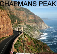
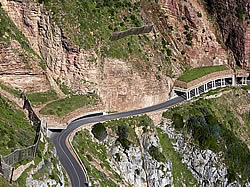
CHAPMANS PEAK |
Contact us for further information concerning the state of the road
Customer Service Line
021 791 8222
Toll Plaza Chapman's Peak Drive:
Tel:
021 791 8220
or
021 790 9163
Chapman's Peak is one of the most beautiful scenic drives in South Africa
Chapman's Peak is the name of a mountain on the western side of the Cape Peninsula, about 15 kilometres south of Cape Town, South Africa.
It is opposite the inlet on which the town of Hout Bay is centred.
|
The top of Chapman's Peak consists of flat, sedimentary rocks related to those that form Table Mountain.
The base of the mountain, however, consists of Cape Granite and the two formations meet at a geological unconformity that is world-famous amongst earth scientists.
A spectacular road, known as Chapman's Peak Drive, hugs the near-vertical face of the mountain from Hout Bay to Noordhoek. Hacked out of the face of the mountain between 1915 and 1922, the road was at the time regarded as a major feat of engineering [1]. Chapman's Peak Drive was closed in the 1990s, following large rockfalls, which killed a driver in her car. The road has since been reopened after being re-engineered to protect motorists from falling rocks.
There is an old, abandoned manganese mine on the northwestern slopes of the peak. The remains of a jetty from which the ore used to be shipped is directly below the workings. |
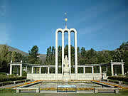
| THE HUGUENOT MONUMENT IN FRANSCHHOEK |
The Huguenot Monument in Franschhoek, South Africa, is dedicated to the cultural influences that French Huguenots have brought to the Cape Colony (and ultimately the whole of South Africa) after their immigration during the 17th and 18th centuries.The monument was designed by J.C. Jongens, completed in 1945 and inaugurated by Dr. A.J van der Merwe on April 7th 1948.
The three high arches symbolizes the Holy Trinity, the Father, Son and Holy Spirit.
Huguenot Monument Franschhoek, is dedicated to the cultural influences that French Huguenots have brought to the Cape Colony (and ultimately the whole of South Africa) after their immigration during the 17th and 18th centuries.
|
The monument was designed by J.C. Jongens, completed in 1945 and inaugurated by Dr. A.J van der Merwe on April 7th 1948.The three high arches symbolizes the Holy Trinity, the Father, Son and Holy Spirit. On top of the arches is the sun of righteousness and above that, the cross of their Christian faith.The central female figure, created by Coert Steynberg, personifies religious freedom with a bible in her one hand and broken chain in the other. She is casting off her cloak of oppression and her position on top of the globe shows her spiritual freedom. The fleur-de-lis on her robe represents a noble spirit and character.The southern tip of the globe shows the symbols of their religion (the Bible), art and culture (the harp), the agriculture and viticulture (the sheaf of corn and grape vine) and industry (spinning wheel).The water pond, reflecting the colonnade behind it, expresses the undisturbed tranquility of mind and spiritual peace the Huguenots experienced after much conflict and strife
.The Memorial Museum neighbouring the monument elaborates on the history of the French Huguenots who settled in the Cape, and especially in the Franschhoek valley. On exhibition are the various tools they used to make wine, clothes they wore and the culture and desire for a better life that they brought with them.Also on the site are wine cellars joined by a colonnade, which bears the words Post tenebras lux (lit. "after darkness [comes] light"). It was the motto of the Protestants during the Reformation, and is also inscribed on the Reformation Wall in Geneva, Switzerland.
|
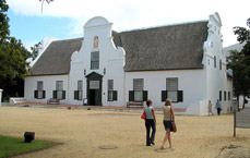
GROOT CONSTANTIA |
info@iziko.org.za
Hours
Daily 10:00-17:00
Close Good Friday and Christmas Day
Entrance fees
Adults R8.00
Children R2.00
Tel : 021 7955140
Fax : 021 7955150
Groot Constantia is one of the oldest wine estates in South Africa.
The manor house is a magnificent example of Cape Dutch architecture and the wine museum pediment is one of the sculptor Anton Anreith's masterpieces
The history of the farm dates back to 1685 when it was granted to its first owner, Simon van der Stel.
He arrived at the Cape in 1679 to take over the post of Commander, later upgraded to that of Governor.
A project to restore the architectural nucleus of the farm, which includes the manor house, started in 1993 and was completed in 1994
The wine cellar houses a Wine Museum exhibiting wine making equipment, especially wine storage and wine drinking vessels.
|
IRMA STERN MUSEUM |
Cecil Road, Rosebank
Cape Town
South Africa
Tel: +27(0)21 685 5686
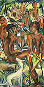
Irma Stern (1894-1966), a major South African artist who achieved national and international recognition in her lifetime.
The permanent collection on display shows Irma Stern’s development as an artist whose subject matter included exotic figures, portraits, lush landsCapes and still lifes conveyed in a variety of media, ranging from oils and water colours to gouache and charcoal.
The Irma Stern Museum was established in 1971 and is the house the artist lived in for almost four decades. Several of the rooms are furnished as she arranged them while upstairs there is a commercial gallery used by contemporary South African artists.
A lively temporary exhibition programme is arranged annually and visitors can enjoy the garden. Content for description Goes Here
|
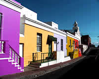
BO KAAP MUSEUM |
71 Wale Street
Cape Town 8000 South Africa
Tel :
+27 21 481 3939
Open Hours9:30a-4:30p M-Sa
www.museums.org.za
As a satellite of the South African Cultural Museum, this museum features exhibits on the Cape Town Muslim community and historical insight into the city's diverse inhabitants. The museum is situated in a restored home in the historic Bo Kaap style, surrounded by other Cape Dutch architecture patinted a spectrum of colors.
Exhibits feature educational explanations and artifacts from the 18th century.
Adults pay R5.oo as an entry fee. Children 6-18 pay R2.00; and, children under 6 years of age are admitted for free.
|
THE SOUTH FRICAN MUSEUM |
25 Queen Victoria St
Cape Town 8001 South Africa
Tel :
+27 (0)21 481 3800
Open HoursDaily 10a-5p
www.museums.org.za/sam
The South African Museum is situated at the top of Queen Victoria Street within the peaceful Company's Gardens. The museum exhibits the largest collection of meteorites in the country, and incredible life-like reproductions of animals, of which fossilised remains were discovered in the Karoo semi-desert.
There is also a whale skeleton, some members of the aquatic world, and examples of flora. Adjoining the museum is the Planetarium, whose projectors replicate the heavens and illuminate the constellations over a 26,000 year time span. Shows and talks are given regularly.
|
TWO OCEANS AQUARIUM |
Two Oceans Aquarium
P.O. Box 50603
Waterfront
8002
South Africa
Tel:+ 27-21-418-3823
Fax:+ 27-21-418-3952
aquarium@aquarium.co.za
The Two Oceans Aquarium is an aquarium located at the Victoria & Alfred Waterfront in Cape Town, Western Cape, South Africa. The aquarium opened on the 13 November 1995 and comprises seven exhibition galleries with large viewing windows:
Atlantic Ocean Gallery
Holcim Activity Centre
Cape Fur Seal Exhibit
I&J Predator Exhibit
Indian Ocean Gallery
Kelp Forest Exhibit
Sappi River Meander Exhibit
Two Oceans Aquarium in Cape Town offers adventure diving with sharks, spectacular function and conference venues and activities for kids.
The Aquarium is also involved in fascinating ocean projects, including shark & sunfish research, and offers exciting environmental education programmes.
|
| |
The Knysna Oyster Company
Oysters are cultivated right here in the Knysna Lagoon and served in most of the local restaurants. The Knysna Oyster Company established in 1949, is situated on Thesen Islands and offers daily educational tours, accompanied by fine cuisine. |
IZIKO PLANETARIUM |
25 Queen Victoria Street
Cape Town
Telephone +27 (0)21 481 3900
Fax : +27 (0)21 481 3990
Email:info@iziko.org.za
Adults : 19 yrs+ : R40,00
Children, students and SA Pensioners R20
Shows Daily
Closed on Workers' Day, Christmas Day and the first Monday of every month (excluding school holidays)
Iziko Planetarium in Cape Town.
The Planetarium can be found at the top of the Cape Town gardens in the buildings of the South African Museum.
The shows are fascinating and have great appeal to people of all ages.
|
Each show is an audio and visual experience and throughout the year there are different themes.
From the comfort of your chair this is a fantastic way to gain a greater understanding and insight into what lies beyond planet earth. While you are in the area allow yourself the time to explore the South African Museum and the Cape Town Gardens.
|
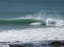
JEFFREYS BAY SURFERS PARADISE |
A very long, fast, tubing right hand point break breaks along the west side of the bay. The break is regarded as one of the best right hand point breaks in the entire world, in both consistency and quality, in season.
It has been divided up into several sections, including, from the top of the point, Kitchen Windows, Magna tubes, Boneyards, Supertubes, Impossibles, Tubes, the Point, and Albatross.
"Supertubes", which itself breaks for about 300m or more, is regarded as the best part of the wave.
On rare occasions (large wave sizes, wide-breaking waves, and even swells), Boneyards can link up all the way to the Point for a ride over one kilometer long. Optimal size is considered to be from about 4 to 10 feet (Hawaiian scale), or about 8 to 20 feet wave faces.
|
The most consistent waves occur between about May to mid September, also often coinciding with offshore winds, although good waves can occasionally occur at other times of the year.[
The initial discovery and promotion of the wave is curious.
Another nearby right hand point wave at St. Francis Bay was first idolised and promoted in the cult classic surf movie The Endless Summer in the 1960s (although both Jeffreys Bay and St. Francis Bay were probably surfed much earlier).
Surfers who travelled to the area soon stumbled upon the nearby Jeffreys Bay surf break, which was found to be not only a faster, more powerful, and hollower wave, but also much more consistent. |
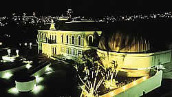
CAMERA OBSCURA |
The Observatory Museum - Grahamstown |
General inquiries:
info@assa.saao.ac.za
10 Bathurst Street, Grahamstown,
Eastern Cape
Monday to Friday
9.30am - 1.00pm & 2.00pm to 5.00pm
. Saturday 9.00am to 1.00pm
Tel +27 (0)46 622 2312
In 1859, Henry Carter Galpin bought a simple double-storey establishment in Bathurst Street for £300.
During the next 23 years he made extensive changes.
The front was elegantly decorated, and a basement and three floors added to the back.
Rooftop developments included an observatory, from which the building took its name, and what was for many years the only Camera Obscura in the Southern Hemisphere.
Born in 1820 in Dorset, England, Galpin trained as an architect, surveyor and civil engineer, as well as a chronometer, clock and watchmaker. These skills, together with his keen interest in optics and astronomy, are reflected throughout The Observatory- the most unusual Victorian home and business premises in South Africa.
Several businesses occupied the ground floor while the basement and upper floors were divided into flats and lodgings.
|
By the end of the 1970s the structure was dilapidated and unsound.
The historic link with the identification of the Eureka diamond led to the purchase and restoration of the Observatory by De Beers Consolidated Mines Limited.
The building was subsequently proclaimed a National Monument and presented to the Albany Museum to form part of its History Division. The Observatory Museum was opened by Mr. Harry F. Oppenheimer, the then Chairman of De Beers, on February 2, 1983 |
PATERNOSTER |
Paternoster Information Centre
Telephone: 27 (0)22 752 2323
Email: paternoster@sbto.co.za
Paternoster Village Tourism,
Situated at the Fish Market on main beach of Paternoster,
Open: Mon-Fri: 09:00-17:00, Sat & Public Holidays: 10:00-15:00
|
| |
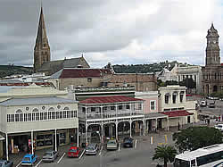
PORT ELIZABETH |
Donkin Heritage Trail.
These include the Campanile (bell tower), built in 1923 to commemorate the arrival of the 1820 Settlers and offering a great viewpoint over the city; the city hall (1862)
Donkin Reserve park and monument
The old stone Fort Frederick(1799).
The Gardens at St George's Park
King George VI Art Gallery
The museum and oceanography room at Humewood
The new Boardwalk waterfront complex. |
| |
THEATRES |
ARTSCAPE THEATRE
Drama, music and dance - theatre for all.
Baxter Theatre
The Baxter Theatre Centre provides an exciting forum for the celebration of life which is the essence of live theatre, music and dance. It is one of the major live theatre venues in Cape Town and has always been at the forefront of the performing arts both as a popular venue and as a leading producer. |
| |
CAPE TOWN HOLOCAUST CENTRE
Memorial to the 6 million Jews who where killed in the Holocaust and all victims of Nazism.
88 Hatfield Street
Cape Town
Tel: 021-462 5553
|
| |
THE SWARTBERG PASS |
The Swartberg pass and its breathtaking view all the way to the top, with some of the best examples of sandstone formations in the world.
Beautiful Meiringspoort with its numerous waterfalls and majestic cliffs.
The Swartberg pass - Meiringspoort circle route will take you about 4 hours to complete.
Visit C.P. Nel Museum one of the best small museums in the world. The world-famous Cango Caves.
The Cango Wildlife Ranch and Crocodile Farm.
Cango Ostrich Show Farm |
http://en.wikipedia.org/wiki/Huguenot_Monument
http://www.irmastern.co.za/index.htm
http://en.wikipedia.org/wiki/Jeffreys_Bay
http://capewestcoastpeninsula.co.za/paternoster/ |
|